For Nonprofits Blog
You're changing the world. We want to help.
From Lake Tanganyika to Google Earth: Using tech to help our communities
Thursday, April 3, 2014
Today we're joined by Dr. Jane Goodall, primatologist and founder of the Jane Goodall Institute and Roots & Shoots program. In this post, Dr. Goodall shares her thoughts on how today’s technology can enable more people around the world to make a difference in their communities. Join Dr. Goodall for a celebratory
Birthday Hangout on Air
today at 11 a.m. PDT/2 p.m. EDT.
-Ed.
When I first set foot on the shores of
Lake Tanganyika
in 1960 to study chimpanzee behavior, I carried with me notebooks, pencils and a pair of second-hand binoculars. I was, at the time, a young woman with no scientific training, but had a strong passion for learning about animals in Africa. In later years I founded the
Jane Goodall Institute
, dedicated to preserving the habitat of chimpanzees and other animals worldwide.
The author connects with a member of the Kasakela chimpanzee community in Gombe.
Photo courtesy of JGI.
Today, the mapping technology available to all of us is completely changing the potential for animal and environmental research. My trip in 1960 would have looked quite different today. You have much more power at your fingertips, and you don't even have to leave your home. Tools like
Google Earth
let you visit the shores of Lake Tanganyika with just a few keystrokes. And in
Gombe
, local villagers are using Android smartphones and tablets, in conjunction with Google Maps Engine and Earth Engine, to
monitor changes in the forest habitat
that affect chimpanzee populations. Technology makes it so easy for people to find and share information and to understand the world around them. And once we understand, we can start to foster positive change.
The Jane Goodall Institute engages local communities from Tanzania, Uganda and across Africa to collect data on forests, wildlife and human activities using Google Android handheld devices.
Photo courtesy of JGI/Lilian Pintea.
That’s one of the reasons we started the
Roots & Shoots
program to connect young people with the knowledge and tools they need to solve problems in their communities. The projects undertaken by these young people help them learn important science, technology, engineering and math (STEM) skills while developing real leadership capabilities. Today, Roots & Shoots is launching a new
community mapping tutorial
for young people to help them use digital mapping technology to identify and address needs in their community. If you’re an educator, we offer online professional development to help you fit our youth leadership model into your classroom and curriculum. You can sign up for the
Roots & Shoots MOOC
to learn more.
Roots & Shoots groups from Uganda, Tanzania, and Republic of Congo share their projects.
There are more than 8,000 Roots & Shoots groups in 136 countries. Photos courtesy of JGI.
Today, on my 80th birthday, my wish is for young people around the world to think about the ways you can use technology to learn more about the wonderful world we share. Then, to take action, and inspire others to do the same. You have the power to do so much more than I did in 1960, to spark change I could only imagine back then. And you can do it no matter where in the world you are.
Posted by Dr. Jane Goodall
Google Maps and giving season
Monday, October 14, 2013
As giving season arrives, we know that many of you are thinking about how to communicate with your donors. Perhaps you’d like to let potential donors know where they can drop off their donations or you’d like to demonstrate where their monetary gifts go. To do this, we’ve seen more and more organizations opting to use visually compelling maps. Check out these stories on how other organizations are using Google Maps to effectively communicate with their donors and make the most of giving season!
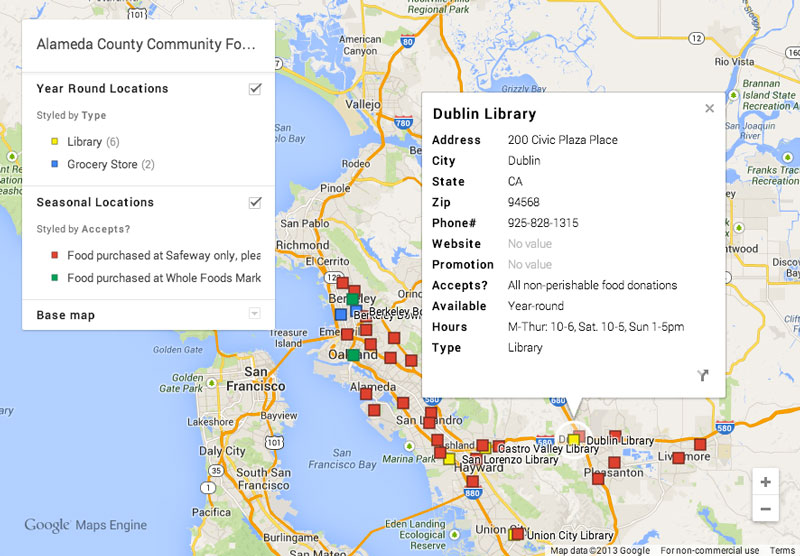
Alameda County Community Food Bank
has been using Google Maps to help potential donors find out where they can donate non-perishable food items to help alleviate hunger in their community. Through this interactive map, donors can see which drop-off location is located closest to them, find out the hours they’re open, what types of donations are accepted and more.
Alameda County Community Food Bank’s donation drop-off locations
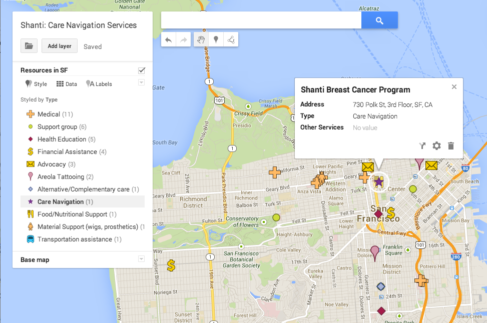
The Shanti Project
assists breast cancer patients in coordinating all stages of their care between low-cost medical services, health education classes, emergency funds and nutritional support so they don't have to figure it all out alone. Shanti is using maps to help its donors visualize the need for the navigation services it offers to their patients.
Shanti’s map of care coordination services
If these examples have given you inspiration for creating your own maps for donors, then we’ve got the perfect tool for you. Earlier this year, Google made it easier to create maps with the launch of
Google Maps Engine Lite
. With Google Maps Engine Lite, you do not need to be a trained cartographer or computer programmer to make your own beautiful, interactive map for your website. In a few simple steps, you can have a map displayed on your website that shows your donation centers, soup kitchens or volunteer locations.
You can start by heading to
Google Maps Engine Lite
and logging in with your Google account. To add locations to your map, you can either search for and add them one-by-one, or you can upload a spreadsheet of your locations with relevant information. Google Maps Engine Lite will help you map those locations quickly. Next, you can choose from different icons and base map styles to make your map more readable and appealing to your donors. You can add and edit information about each location directly in the map as well, so it’s very easy to add more locations down the line, or remove locations you no longer use. Once you’re happy with your map, simply click the “Share” button to get a link or the folder icon to get the HTML embed code to put it on your website. You can find the detailed instructions to walk you through all these steps in our
tutorial
.
To learn more about Alameda County Community Food Bank, Shanti and how to create maps with Google Maps Engine Lite, check out our
Hangout on Air
. Happy mapping!
Posted by Allison Lieber and Raleigh Seamster, Google Earth Outreach team
Inspiring awareness and engagement with Google Earth Outreach
Wednesday, June 12, 2013
Whether it’s YouTube videos, Google+ events or Google’s mapping tools, we’re constantly inspired by the ways nonprofits tell their stories and spark community action. We’d like to share the work of three environmentally focused nonprofits who have used Google Earth and Maps to raise awareness and encourage involvement.
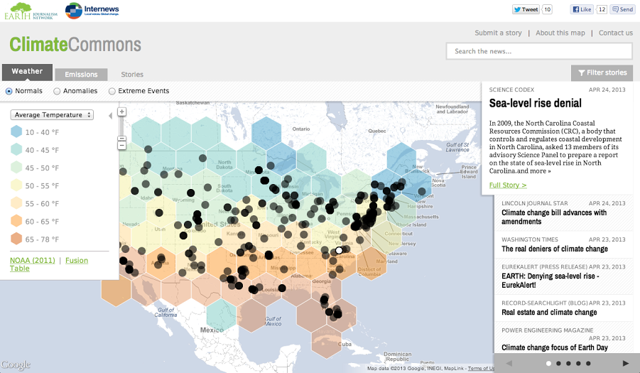
Climate Commons Map
Internews’
Earth Journalism Network
recently launched
Climate Commons
, funded with a
Google Earth Outreach Developer Grant
. Climate Commons is an interactive map that aims to track the impacts of and responses to climate change on a local, regional and national level across the United States. The map overlays relevant data showing climate change indicators (temperature, precipitation, emissions, etc.) with the latest, geo-tagged stories about climate change from around the US. Check out the
Climate Commons map
to explore both the climate change data and the media coverage around it.
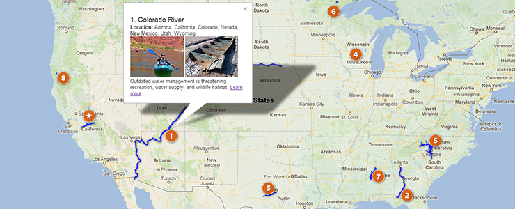
American Rivers Map
Every year,
American Rivers
names 10 rivers as America’s
Most Endangered Rivers
because they are facing specific threats and because their uncertain fates will be decided in the coming year. Using
Google Maps Engine
, American Rivers built an interactive map that allows users to explore the rivers and learn more about how they can get involved. Try out the map for yourself
here
.
EOL Monarch Butterfly Tour
Each year, Danaus plexippus, also know as the eastern monarch butterflies, begin a migration across North America. To illustrate the butterflies’ epic journey, the
Encyclopedia of Life Learning + Education group
and
Atlantic Public Media
produced a
Google Earth Tour of their migration
. The tour is coupled with
companion podcasts
, adding additional insights and commentary to this geographic storytelling. Begin exploring the migration with
this kml file
, or with the video below.
If you’d like to use Google Earth and Maps to help tell your story, you can get started by visiting the
Google Earth Outreach site
or watching
our video tutorials designed specifically for nonprofits
. You can also apply for a Google Maps Engine grant
here
.
Posted by Raleigh Seamster, Google Earth Outreach team
Get started with Google Earth through step-by-step tutorials
Friday, April 5, 2013
Using maps is a powerful way to visually share data and truly make your story come alive. Our partners at
Google Earth Outreach
are constantly helping nonprofits share those stories. For the last two weeks, they’ve joined us and shared how your nonprofit can get the most from Google Earth Outreach through tips, stories and Hangouts on
our Google+ page
. In case you missed any of that information, check out the tutorials below to learn step-by-step how to build, not only maps on Google Earth, but also presentations and movies.
1. Create your own interactive map on Google Earth.
Follow
the tutorial below
to show your users and donors the impact you’re making in a particular area. Enhance your map by adding placemarks, paths, polygons, photos and YouTube videos.
2. Overlay an existing map in Google Earth.
If you have a map image such as a trail map or political map that you’d like to bring into Google Earth, check out
this Hangout
to learn how to overlay your map in Google Earth and customize it to better tell your story.
3. Build powerful presentations using Google Earth.
Google Earth can help you make compelling presentations by adding unique views and perspectives to your locations. Check out
this video
to see how you can visually walk stakeholders or the public through your story.
4. Make your own movie with Google Earth.
Guide your viewers through an issue or project by creating an animated movie in Google Earth.
This Hangout
will show you how to record your movie and share it with your users.
Need a few more examples to help you get started? We hosted a fifth Hangout with previous recipients of
Earth Outreach Developer Grants
. The grantees discussed the work their organizations do and how they're each using Google Earth and Maps for good. To learn more about how they are using these products, watch
the Hangout
. To find out more about the Google Earth Outreach Developer Grants, visit
this site
.
If you want to see more Google Earth Outreach tutorials, visit the
Google Earth Outreach site
. And if you have questions as you use Google Earth, check out the
Google Earth User Forum
and post your question there.
Posted by Kousha Navidar, Google for Nonprofits team
Google Maps shows Amazon funds at work
Wednesday, March 27, 2013
(Cross posted from
the Lat Long Blog
)
Editor’s Note:
Today’s guest author is Gabriel Ribenboim from
Ritual
, on behalf of
Amazonas Sustainable Foundation
(FAS), a nonprofit organization implementing a large-scale social and environmental program in the Amazon. FAS was the recipient of a
Google Earth Outreach Grant
for Google Maps Engine, which they used to develop an accountability map for their investments in conservation and poverty alleviation. We are excited to showcase the Bolsa Floresta Platform. Our work with FAS is an example of how non-profits all over the world are using comprehensive, accurate and easy-to use Google Maps, Earth and geo tools to tell their story and help their audiences visualize their cause.
Since 2011, I’ve been working with the Brazilian nonprofit organization
Amazonas Sustainable Foundation
(FAS) and Google to collect
Street View for the Amazon
. One FAS’s most significative initiatives is the administration of the Bolsa Floresta -- Brazil’s first internationally-certified incentive program for the preservation of traditional communities and environment in the Amazon rainforest. As the largest payment for environmental services program in the world, Bolsa Floresta serves over 35,000 people, 15 state-protected reserve territories and covers an area of more than 10 million hectares.
Today, I’m excited to announce FAS’ latest project with Google: the Bolsa Floresta Platform - an online tool that allows you to explore and visualize a mix of social, environmental and economical map datasets for 15 protected areas in the Amazon.
Institutional transparency is a challenge for NGOs across the world. Tools that help track the impact of our efforts and present them in an accessible way are rare and normally require a significant investment. The Bolsa Floresta platform, built on Google technologies such as Google Maps Engine, Google Drive, YouTube and Street View helped us organize this kind of dataset in a way that is easy to visualize, understand and share with little in the way of programming complexity or investment.
Now, anyone can dive into the mapping visualizations of the State of Amazonas, navigate the rivers, forest, and communities through Google Street View imagery, or even browse 3D buildings inside protected areas. Most importantly, partners, government agencies and those who live within the benefited state-protected areas, can explore all kinds of informational map layers, enhancing institutional transparency, global awareness, exchange of sustainability practices and poverty alleviation solutions and improving internal planning capabilities.
The new platform is just one of the many ways FAS is using Google’s technologies to work towards a sustainable future on behalf of the communities of Brazil’s Amazon.
Explore the map now
or find out more about us at
fas-amazonas.org
.
Posted by Gabriel Ribenboim from
Ritual
, on behalf of
Amazonas Sustainable Foundation
(FAS)
Make a map that will change the world with Google Earth Outreach Developer Grants
Wednesday, March 13, 2013
For the third year, I’m excited to announce the call for 2013 Google Earth Outreach Developer Grants applications is now open.
Google Earth Outreach Developer Grants
provide funding to nonprofit organizations ranging between $10,000 and $20,000 on average to build a map that will help them accomplish their mission, be it around environmental issues, humanitarian causes, disaster relief prevention, or health issues. If your nonprofit has a great idea for a map that can change the world,
apply for a 2013 Google Earth Outreach Developer Grant today
. This year, we checked in with our
2011 Developer Grantees
to learn about the impact their maps had on each nonprofit’s overall mission one year after the launch of the map. We were proud of the many achievements of the nonprofits’ work. Here are some of my favorite examples:
WWF & Eyes on the Forest mapped deforestation rates and wildlife habitat in Sumatra.
WWF & Eyes on the Forest
created a map to showcase deforestation in Sumatra. With the Google Maps Engine map as part of their “
Don’t Flush Tiger Forests
” campaign, they convinced 17 out of 20 US retailers to stop buying toilet paper from companies cutting down intact hardwood rainforests and critical tiger habitat in Sumatra.
The HALO Trust mapped their minefield clearance work in a Google Earth Tour
The HALO Trust clears minefields in previously war-torn regions around the world, including Angola, Afghanistan and Cambodia. Upon the launch of their
Google Earth tours
designed to raise awareness about their work, they saw the most traffic to their website over the entire calendar year.
iNaturalist taps into citizen scientists who submit research-grade species observations to a global map using Android devices and iPhones
iNaturalist.org’s Android app, designed to collect species observations from around the world from citizen scientists, has been installed on over 2000 Android devices. The number of scientific-grade research observations has more than quadrupled. We look forward to hearing about the impacts of our
2012 Developer Grantees’
maps as they are launched in coming months. Good luck to nonprofits who apply to our
2013 Google Earth Outreach Developer Grants
, and if you are a nonprofit with a great idea for a map,
apply for a grant
!
Posted by Tanya Birch, Google Earth Outreach
How mapping technology is helping Chief Almir and the Surui Tribe protect their culture and environment
Wednesday, January 23, 2013
We are always excited to see how nonprofits use Google products to help change the world. One story that we think is especially inspiring is that of Chief Almir and the Surui Tribe.
The Surui people of the Brazilian Amazon had their first contact with outsiders in 1969. While the first encounter brought disease and deforestation, later contact helped bring about cultural preservation and environmental protection.
Their tribal leader, Chief Almir, first came across Google Earth in 2007 in an internet cafe. He recognized its potential for conserving the heritage and traditions of his people that were being threatened by the deforestation of the Brazilian rainforest.
He has embraced the mapping technology as a way to protect the rainforest and preserve his people's way of living. Check out their story below or
read more here
.
Want to learn more about how other nonprofits are using Google for Nonprofits? Check out this full case study and others on the
Google for Nonprofits site
. If you’re interested in sharing your story, we’d love to hear it. Share it with us on
our Google+ page
.
Posted by Raleigh Seamster, Google Earth Outreach team
Google Earth Outreach launches in Australia and New Zealand
Tuesday, November 6, 2012
(Cross posted from the
Google Australia Blog
)
Great Barrier Reef coral health, fire management, and depleting forest cover are some of our nation’s greatest environmental challenges. But up until now it has
been a challenge to bring large-scale environmental issues (that might affect hundreds of thousands of acres) to life in a meaningful way. To help address this, we’re bringing
Google Earth Outreach
to Australia and New Zealand.
With Google Earth Outreach,
nonprofit organisations can use Google mapping tools to visualise their causes and tell their stories to millions of people around the world.
See
how nonprofits and researchers are using Google mapping tools.
Across the globe, nonprofits have used Google Earth Outreach to
help clear landmines
in Cambodia and Angola, and to
demonstrate forest and wildlife loss
in Sumatra, Indonesia.
At last night’s
official launch event
at Macquarie University, we announced new projects with three Australian partners.
Dr. Elizabeth Madin from
Macquarie University
demonstrated how her team is using Google Earth to further
her work
in investigating coral reef landscapes; they integrate ecological theory and
the high-resolution satellite imagery available in Google Earth to identify “grazing halos”, which may be able to tell us more about coral reef health.
The
Great Barrier Reef Marine Park Authority
launched an
interactive map
, which will shows how their
Reef HQ Aquarium
is bringing the Great Barrier Reef to students around the world. They also launched a
Google Earth narrated tour
following the track of Torres the Green Turtle as he swims along the Great Barrier Reef and meets incredible marine life along the way.
The
Australian Wildlife Conservancy
also unveiled two Google Earth tours. The
first tour
flies through their 23 sanctuaries which cover more than 3 million hectares to bring to life their fight to save Australia’s unique wildlife from extinction. The
second tour
overlays AWC geospatial data on top of Google Earth to demonstrate the impact of their EcoFire Project in the Kimberleys over the last six years.
Take the new Google Earth tour
from AWC
If you’re a nonprofit interested in learning more about the Google Earth Outreach program, check out
our website
. There you’ll find
tutorials
and a showcase of
nonprofit success stories
, and you can also
apply for grants
for Google Earth Pro, Google Maps Engine, Google Maps API for Business, and Google Maps Coordinate.
We hope that by bringing this program to Australia and New Zealand, many more organisations will be able to tell powerful visual stories about the important work they do, to both help them raise awareness and funds and further their scientific goals.
Posted by Raleigh Seamster, Program Manager for Google Earth Outreach
Announcing The Winners Of 2012 Google Earth Outreach Developer Grants
Thursday, November 1, 2012
(Cross posted from Geo Developer Blog)
In 2011, Google Earth Outreach
launched
a new program to fund nonprofits that want to create cutting-edge maps for public good. Today, we’re excited to announce the winners of the
2012 Google Earth Outreach Developer Grants program
. We’ve selected eight nonprofit organizations, listed below, that have presented a compelling ideas for a new map or mapping technology that will make a positive impact on the world. Each winner received a grant to support the technical development of their map. The winners include:
The Royal Canadian Geographical Society
- A Developing World: a Maps API application containing UN Human Development Index data
Clinton Health Access Initiative
- Getting to Zero in Southern Africa: A Temporal and Spatial Map of Malaria Progress
SamSamWater Foundation
- Rainwater Harvesting Tool: Calculate Your Drinking Water using Google Maps
Wild South
- Cherokee Trails: Google Earth tours, a map, and an Android app documenting Cherokee Indian geography and the struggle of the Cherokee to remain in their homeland.
Internews
-Change of States Map: a Maps API application documenting local impacts and adaptations to climate change in the US.
Vanishing Worlds Foundation / World Oral Literature Project / Language Landscape - Language Landscape:
an Extensible Model for Mapping Language Dynamics
the Jane Goodall Institute
- Community-based Forest & Wildlife Monitoring: Scaling Up and Sharing Dynamically Generated Maps
Atlantic Public Media
- Monarch Migration: a Google Earth Tour
Work is already in progress on each of the projects, so check back on our
Developer Grants
page in the coming months to see these maps come to life, and to explore maps created by last year’s grantees.
Watch this video to see an example of a Google Earth Tour made possible by the 2011 Developer Grants program is the
Arctic Tern Migration
, created by the Atlantic Public Media. We’re very excited about the organizations that were funded this year, and we wish to thank these hardworking organizations who are improving conditions for people and the planet.
Posted by Tanya Birch, Google Earth Outreach
*These organizations were funded through the Google Inc. Charitable Giving Fund at the
Tides Foundation
.
Google Maps Coordinate Grants for Nonprofits
Thursday, October 11, 2012
Google Earth Outreach
is happy to announce the latest offering in our Grants program: Google Maps Coordinate.
Google Maps Coordinate
is a workforce management tool that allows organizations to quickly and easily assign jobs to field workers, improving operational efficiency and communication. Coordinate lets a dispatcher team have real-time visibility into the locations of the field workers, and they can send job assignments directly to their mobile devices. In the field, mobile workers can accept jobs, add relevant information to each job assignment, keep their dispatchers updated, and work more efficiently knowing where all the other field workers are.
We’re looking forward to helping nonprofits use Google Maps Coordinate to do things like deploy urban forestry teams, urban car-sharing services, or mobile health workers to conduct surveys in villages.
The Android Google Maps Coordinate app enables complete offline job access, so you can accept, check-in, and complete jobs include any notes on the job offline. Your updates will sync as soon as you’re back online.
Learn more
about how Google Maps Coordinate works. Eligible nonprofits in the U.S., U.K. and Canada are welcome to
apply for a Google Maps Coordinate grant
today.
Posted by Tanya Birch, Google Earth Outreach
Maps For Good: Google Earth Outreach Developer Grants 2012
Thursday, July 19, 2012
(Cross posted from
the Lat Long Blog
)
In 2011, the
Google Earth Outreach
team
awarded
a first round of
Developer Grants
to organizations with outstanding mapping ideas. These grants support the technical development of maps and enable nonprofits to implement cutting-edge mapping technology to make an impact on the world.
This year at
Google I/O
, we announced the
2012 Google Earth Outreach Developer Grants program
in a session called “
Maps for Good
.” We were honored to have two developers speaking on behalf of organizations who were awarded a Developer Grant in 2011, including Jake Wall from
Save the Elephants
and Kevin Bluer from
AXS Map
.
Learn more
about their projects, as well as other 2011 grantee work for inspiration on how mapping could bring your nonprofit’s work to life.
Over the past few months, we’ve seen more nonprofits
making use of tools like Google Maps Engine
and developing
applications on Android devices
. We expect to see project proposals with innovative ideas that address the world’s most pressing problems in the areas of the environment, humanitarian issues, disaster preparedness, at both the local and global level.
Be inspired by how mapping can help spread your nonprofit’s message
Visit the
Google Earth Outreach
website to learn more about this year’s
Developer Grants program
and make sure your organization is in an eligible country. The deadline to apply with your initial project proposal is August 1, 2012 at 11:59pm PST.
Good luck to all of this year’s applicants!
Posted by Tanya Birch, Google Earth Outreach team
The HALO Trust Uses Google Earth To Help Get Mines Out Of The Ground, Now
Wednesday, June 6, 2012
(Cross posted from
the Lat Long Blog
)
Founded in 1988,
The HALO Trust
is the world’s oldest and largest humanitarian landmine clearance organization. Dedicated to the removal of the hazardous debris of war, HALO has cleared over 414,000 acres of land and removed over 13 million landmines and other explosive remnants. Their work allows families to return home, land to be used for agriculture, roads to be re-opened, and children to walk to school safely. When HALO visited the
Google Earth Outreach
team at Google headquarters two years ago, we were proud to hear
how they use our tools to clear landmines around the world
. Since 2006, they have leveraged their Google Earth Pro grant for minefield survey, data validation, quality control and to produce maps for donors, governments, and other NGOs. They have since received a
Google Earth Outreach Developer Grant
to fund creation of their
Explore a Minefield
project. Now you can take a tour of the mine-affected areas of Cambodia and Angola with the HALO Trust using
Google Earth
, and see how landmine removal efforts have helped build safe and vibrant communities. Angelina Jolie, who has visited mine removal efforts in a number of war-torn countries, lent her voice for the narration.
Learn how HALO’s Cambodia staff maps and clears mined areas. Watch the
YouTube video
or
download the tour
in Google Earth.
Watching these tours, we were amazed at the sheer number of mines that were laid in Cambodia and Angola and the size and scope of HALO’s effort to clear them in each of the
13 countries where they work
. Using Google Earth’s
historical imagery
to provide time-lapse images of mined areas before and after clearance, they can clearly show how landmine removal is helping war-torn communities rebuild. While this scale of landmine clearance is staggering and inspiring, the tours also show the minefields that still remain.
Learn about Angola’s war-torn history and how HALO is helping communities to rebuild. Watch the
YouTube video
or
download the tour
in Google Earth.
To learn more about how you can help The HALO Trust clear these remaining minefields, visit
their website
.
Posted by Raleigh Seamster, Google Earth Outreach
Google Maps Engine Grants For Nonprofits
Tuesday, May 22, 2012
(Cross posted from
the Lat Long Blog
)
Today, we are excited to announce a new addition to the
Google Earth Outreach Grants program
. Now, eligible nonprofit organizations in the U.S., U.K., Brazil and Canada can apply for grants of
Google Maps Engine
, a
platform formerly known as Google Earth Builder
, for hosting, storing, managing, and styling map data. Google Earth Builder has been
available to businesses
since August 2011. A new name is just the beginning. Several nonprofit organizations, including
World Wildlife Fund
and
Eyes on the Forest
(a coalition of Sumatran NGOs), as well as
Living Oceans Society
, have already been using the platform to tell stories and engage their constituents in an interactive way. It's no secret that the natural habitats of wildlife such as tigers, rhinos, elephants and orangutans are disappearing at an alarming rate. The World Wildlife Fund, in partnership with Eyes on the Forest, uses Google Maps Engine to develop and publish Geographic Information Systems (GIS) data showing the reduction of ranges for these four endangered species. In addition, they are publishing maps on floral diversity and change in carbon stocks and forest cover over time.
While some nonprofits focus on terrestrial conservation, Living Oceans Society works to protect the British Columbia coastline. As GIS and mapping specialists, they create and publish maps such as kayak routes, dive sites, eelgrass beds, and oil and tanker traffic to inform residents of the recreational value of natural habitats as well as inform policy-makers about the risks that increasing industrial practices pose to the ecosystem.
With this addition of Google Maps Engine to the Google Earth Outreach Grants program, we’re releasing three new Google Maps Engine
tutorials
to educate nonprofits on how to use the product. We’ll also be hosting a Google+ Hangout on the
Google Earth Plus page
to provide more information about the program and answer questions from potential grant recipients. Tune in by visiting the Google Earth Plus page on May 24th at 10:30 a.m. PDT to join the
Hangout on Air
. More information about eligibility for a Google Maps Engine grant and how organizations can apply is available on the Google Earth Outreach
Maps Engine for Nonprofits page
.
Posted by Tanya Birch, Program Manager, Google Earth Outreach
Why Maps Matter: Using Digital Cartography Tools To Change The World
Friday, March 30, 2012
(Cross posted from
the Lat Long Blog
)
People have created maps since early civilization, but only recently have digital mapping tools like
Google Earth
and
Maps
made it easy to build sophisticated and interactive maps that can be disseminated to hundreds of millions of people online. Non-profits have taken advantage of these tools to create maps that matter, and that are truly initiating change around the world. That’s why my team,
Google Earth Outreach
, exists: to help public benefit organizations use Google’s mapping tools for good.
Find out how non-profits are changing the world with maps.
There’s no better inspiration for creating your own map than the stories of accomplishment from organizations like the ones featured in the video above. We invite you to check out the new
Success Stories
section of the
Google Earth Outreach website
. Along with a completely new look and feel, our website now allows you to learn all about a variety of organizations that are using maps for good.
Get started by reading about how the
Amazonas Sustainable Foundation
partnered with Google to collect
Street View imagery for the Amazon
. It’s now possible to virtually float down the Rio Negro and its tributaries, see ground-level images of riverside communities, and trek down a trail into the Amazon rainforest, all without leaving the comfort of home. You’ll also learn about
Architecture for Humanity
, an organization using
Google SketchUp
to design architectural solutions for communities in need.
Collecting Street View imagery in the Amazon
Once you’ve read through the stories and have an idea of what you might like to create, you can browse through
our tutorials
or
request a software grant
for our enterprise-level products like Google Earth Pro. Or, if you’re interested in an overview of all the tools available to you from Google, feel free to check out our
Explore Tools page
, where you’ll find information about the many Google mapping tools (both free and Pro) that are available to non-profits.
If you’re looking for additional training beyond the tutorials, check out our new
Events page
, where you can see where Google Earth Outreach will be next and where we’ve been in the past, including rich resources from past workshops.
If you want to change the world, we hope these new tools help. Happy mapping!
Posted by Raleigh Seamster, Google Earth Outreach
Labels
AdWords Basics
98
AdWords in the Curriculum
9
Google Analytics
9
Google Apps
25
Google Apps Highlights
10
Google Earth
18
Google Earth Outreach
28
Google for Nonprofits Blog
529
Google Fusion Tables
2
Google Maps
10
Google Products
63
Google Sketchup
2
Google+
16
Grantees
98
Grants Program
97
Optimization
59
Program Alerts
15
Resources for Non-Profits
179
Tracking Performance
35
YouTube
26
Archive
2016
Sep
Aug
Jul
Jun
Apr
Mar
Jan
2015
Nov
Sep
Aug
Jul
Jun
May
Apr
Feb
2014
Nov
Oct
Aug
Jul
Jun
Apr
Feb
2013
Dec
Nov
Oct
Sep
Aug
Jul
Jun
May
Apr
Mar
Feb
Jan
2012
Dec
Nov
Oct
Sep
Aug
Jul
Jun
May
Apr
Mar
Feb
Jan
2011
Dec
Nov
Oct
Sep
Aug
Jul
Jun
May
Apr
Mar
Feb
Jan
2010
Dec
Nov
Oct
Sep
Aug
Jul
Jun
May
Apr
Mar
Feb
Jan
2009
Dec
Nov
Oct
Sep
Aug
Jul
Jun
May
Apr
Mar
Feb
Jan
2008
Dec
Nov
Oct
Sep
Aug
Jul
Jun
May
Apr
Mar
Feb
Feed
Google
on
Follow @googlenonprofit
Follow


 Follow