For Nonprofits Blog
You're changing the world. We want to help.
Inspiring awareness and engagement with Google Earth Outreach
Wednesday, June 12, 2013
Whether it’s YouTube videos, Google+ events or Google’s mapping tools, we’re constantly inspired by the ways nonprofits tell their stories and spark community action. We’d like to share the work of three environmentally focused nonprofits who have used Google Earth and Maps to raise awareness and encourage involvement.
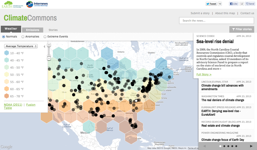
Climate Commons Map
Internews’
Earth Journalism Network
recently launched
Climate Commons
, funded with a
Google Earth Outreach Developer Grant
. Climate Commons is an interactive map that aims to track the impacts of and responses to climate change on a local, regional and national level across the United States. The map overlays relevant data showing climate change indicators (temperature, precipitation, emissions, etc.) with the latest, geo-tagged stories about climate change from around the US. Check out the
Climate Commons map
to explore both the climate change data and the media coverage around it.
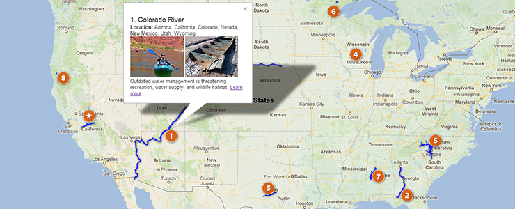
American Rivers Map
Every year,
American Rivers
names 10 rivers as America’s
Most Endangered Rivers
because they are facing specific threats and because their uncertain fates will be decided in the coming year. Using
Google Maps Engine
, American Rivers built an interactive map that allows users to explore the rivers and learn more about how they can get involved. Try out the map for yourself
here
.
EOL Monarch Butterfly Tour
Each year, Danaus plexippus, also know as the eastern monarch butterflies, begin a migration across North America. To illustrate the butterflies’ epic journey, the
Encyclopedia of Life Learning + Education group
and
Atlantic Public Media
produced a
Google Earth Tour of their migration
. The tour is coupled with
companion podcasts
, adding additional insights and commentary to this geographic storytelling. Begin exploring the migration with
this kml file
, or with the video below.
If you’d like to use Google Earth and Maps to help tell your story, you can get started by visiting the
Google Earth Outreach site
or watching
our video tutorials designed specifically for nonprofits
. You can also apply for a Google Maps Engine grant
here
.
Posted by Raleigh Seamster, Google Earth Outreach team
Labels
AdWords Basics
98
AdWords in the Curriculum
9
Google Analytics
9
Google Apps
25
Google Apps Highlights
10
Google Earth
18
Google Earth Outreach
28
Google for Nonprofits Blog
529
Google Fusion Tables
2
Google Maps
10
Google Products
63
Google Sketchup
2
Google+
16
Grantees
98
Grants Program
97
Optimization
59
Program Alerts
15
Resources for Non-Profits
179
Tracking Performance
35
YouTube
26
Archive
2016
Sep
Aug
Jul
Jun
Apr
Mar
Jan
2015
Nov
Sep
Aug
Jul
Jun
May
Apr
Feb
2014
Nov
Oct
Aug
Jul
Jun
Apr
Feb
2013
Dec
Nov
Oct
Sep
Aug
Jul
Jun
May
Apr
Mar
Feb
Jan
2012
Dec
Nov
Oct
Sep
Aug
Jul
Jun
May
Apr
Mar
Feb
Jan
2011
Dec
Nov
Oct
Sep
Aug
Jul
Jun
May
Apr
Mar
Feb
Jan
2010
Dec
Nov
Oct
Sep
Aug
Jul
Jun
May
Apr
Mar
Feb
Jan
2009
Dec
Nov
Oct
Sep
Aug
Jul
Jun
May
Apr
Mar
Feb
Jan
2008
Dec
Nov
Oct
Sep
Aug
Jul
Jun
May
Apr
Mar
Feb
Feed
Google
on
Follow @googlenonprofit
Follow


 Follow